Support this website by joining the Silver Rails TrainWeb Club for as little as $1 per month. Click here for info.


This website has been archived from TrainWeb.org/bayshorehs to TrainWeb.US/bayshorehs.

South Orchards

Click image to view a larger version.

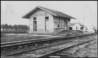
South Orchard was primarily an agricultural stop, while Fowl River provided both outbound loads as well as the location for the water tower servicing northbound trains.

The image to the right shows the station as it appeared in 1915. The timetable places the stop only 1/2 mile north of Fowl River's station and water tower. If that distance is correct, then the second of these possible locations would be more accurate.

In the large area image at left, there are two possible locations for the station. The first possible location would be in the cluster of farming tracts seen at the top of the image. The second location is at the far bottom of the image.

The image at left is an enlargement of the first possible site, showing the area in the middle of the farm tracts.

The image at right shows the second possible location for South Orchard's tiny station. Note how the roadbed appears to bulge outward as if to allow for a passing track.

ad pos61 ad pos63
ad pos62 ad pos64


Support this website by joining the Silver Rails TrainWeb Club for as little as $1 per month. Click here for info.