


This website has been archived from TrainWeb.org/oldtimetrains to TrainWeb.US/oldtimetrains.

CPR Vancouver Yards circa 1953
Andy Cassidy Collection
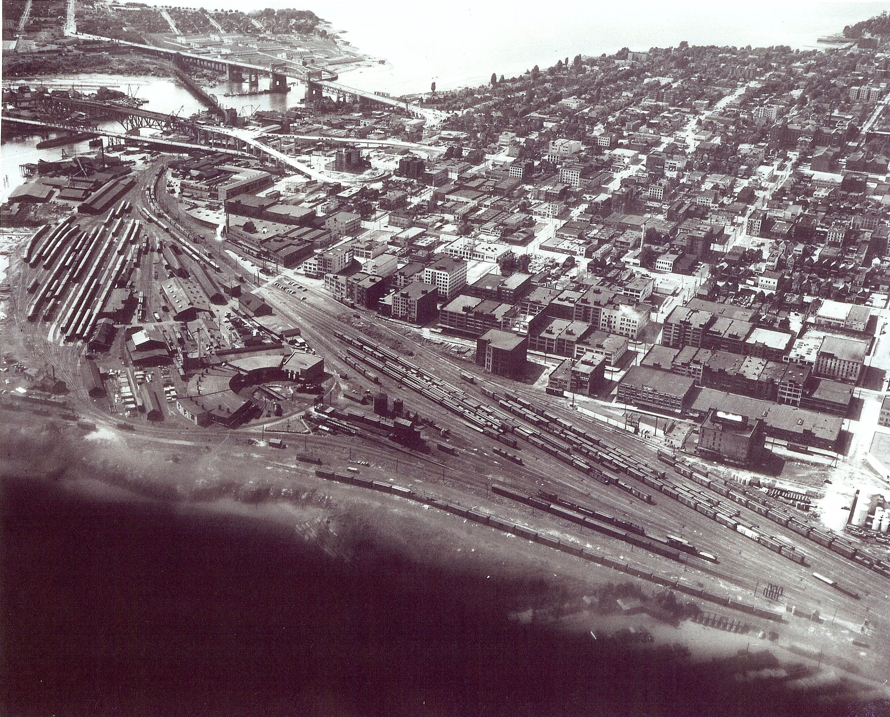
Vancouver Yards
Andy Cassidy
This aerial view is likely dated 1953 based on the Granville
Street bridge construction at the upper left. There are a number of interesting
features in this photograph. First off, all the trains come into Vancouver
on the other side of downtown which is way over to the top left of this shot.
From there some freight and all the passenger equipment came over to this
side of town through the Dunsmuir Tunnel that exited out just a bit east beyond
the Cambie Street Bridge. The freight cars were marshalled around the Centre
Yard that ran closest to the downtown buildings. You can also see some passenger
equipment stored in about the middle there. Farther west from there was where
the BC Electric Railway, (BCER), interchanged their traffic. They came and
went over the Kitsilano Trestle that you can see going diagonally between
the Burrard Street Bridge and the newly constructed Granville Street Bridge.
If you have a close look at the Burrard Bridge, you can see that it was designed
to accept a rail bridge on its lower level, although this was never utilized.
The Kits trestle was removed in 1982 along with the rest of the rail infrastructure
in the photo to make way for Expo 86. The whole area is high-rise buildings
now.
Carrying on looking at the yard. At the bottom closest to the water you see
the tracks that run along the south leg of the "Y" and over to the
Coach Yard at the far left. This is all Q-Yard. At the time of this photo
this area of the operation was a going concern. Passenger operations were
the mainstay. At the bottom right is where the Wash Rack is located, and just
south of that are those other tracks that seem to be where they are ripping
out the broken grain doors from the box cars there. The "Y" was
used to turn engines and cars for the trip back east. That runs on the south
side of the roundhouse over towards the shed where they used to clean carpeting
from the coaches just before going into the coach yard. Then it goes right
in front of the turntable heading north over the crossings and northwest up
past the Stores Warehouse and Office buildings. That road crossing the yard
into downtown at that point is Drake Street.
Looking at the shop complex there starting at the middle of the photo is the
loco servicing area. There is no infrastructure in place here at that time
for Diesels. That comes soon after. If you look close you can see features
such as the water tower, sand shed and tower, oil tank, coal chute, etc. Now
another lost point that many are unaware of is the garden that was kept there
by the guys. That is that triangular patch in the south corner of the "Y".
Look close. Now looking at the Roundhouse you can see a few loco's sitting
outside. All those bays on the south side were handed over to CP Transport
some years later. I'm quite sure they got the ten bays on that side. Then
what was left was renumbered from 1 to 12. Pit 1 was where we kept the oil
car for the shop boiler operation. Pit 2 was where the 2860 was later kept
till rebuilt in 1975. Pits 3 to 9 were used for servicing etc. And pits 10
to 12 were the newer addition that had the overhead crane installed and on
track 11 was where we had the 35 ton jacks to lift the diesel units to pull
trucks out. Directly behind the roundhouse was the Machine Shop where all
the metalworking etc was done. And beyond that was the Administration Building,
Electrical Shop, Upholstery Shop, Car Repair Shop, Car Drop Table and Rabbit,
Wheel Lathe, and so on. You can see the boiler house stack just behind the
roundhouse to the south of the Machine Shop building.
The buildings running parallel to the Coach Yard track are the Coach Yard,
Office, Electrical, Plumber, Car Cleaners, Dining Car Services, Etc. Up at
the top left is the area where Johnston Terminals was located. I'm not sure
if they were there at the time of this shot. Just up from that you can see
another bridge crossing False Creek and that's the 2nd Granville Street Bridge
that was torn down once the new one was finished in 1954. You can see it has
a swing span for marine traffic.
There are many other items of interest to people who know the area, but the
last thing I'll note is the area at the top middle just to the north west
of the Burrard Street Bridge, and that's the RCAF storage depot that is now
Vanier Park, once an Indian Reserve. Looking to the right out of the photo,
is the BCER Carrall Street Yard.