Support this website by joining the Silver Rails TrainWeb Club for as little as $1 per month. Click here for info.


This website has been archived from TrainWeb.org/omaha to TrainWeb.US/omaha.

   CStPM&O & CNW

Hannibal Wisconsin

     Hannibal is one town of the few that were on the stretch of Count "M" that survived fairly well after the railroad departed. It is located the crossroads of State highway 73 and County trunk "M" which I am certain helped it prosper. This town of about 100 people had many new buildings which replaced the old, but memories of the current or one time residents still hold the key to the past. Old general stores, hotels, repair shops and the like are still located near the old "right of way" of the Stanley Merrill and Phillips coming in from the South from Gilman heading for Jump River and the Omaha coming in from the West. As time goes on, we will learn about where the train right of ways entered and left, what business they served, and memories of the past that reflect a time that helps build atmosphere to any particular time of interest. The rails would have entered at the beginning of the last century and lasted about 40 years. There should be some confidence in the statement that the railroads helped increase the amount of residents in the area in the nature of services for transportation of goods, whether dry or wet. People needed to ship crops or receive a piano or tractor and the railroad would be there to help them fulfill their needs. One would think that there was at least a moment of sadness when the rails washed out from the West and service was stopped from the South. Reflecting back on the time, residents may not have been aware of the impact this change would create until later.

Main PageAnson WisconsinJim Falls WisconsinCobban WisconsinHatch's SpurHatch's SpurCornell WisconsinHolcombe WisconsinArnold WisconsinDonald WisconsinHannibal WisconsinHughey WisconsinRuby Wisconsin

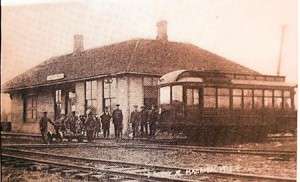
The Depot

This is a picture of the Hannibal Depot sometime around 1905. A close look at the little Doodle-bug may represent a vehicle from the Soo line or Stanley Merrill and Phillips on the cross tracks that connected Jump River and Stanley.

Courtesy of Emil Gerber from "The making of Jim Falls and Area"


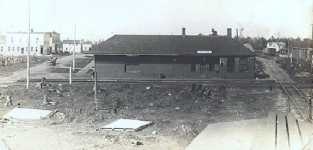
This picture was taken from the top of a box car. A freight addition was added to the depot
sometime in the 20's as the town grew and the need for shipments increased. CSTPM&O is believed to be left to right and SM&P would have been on the right seen top to bottom.


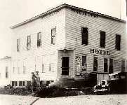
My stepfather was Lawrence Larmon, and he operated the store in the picture from the 1930's until about two weeks before he died March 8, 1997, at the age of 91. His father, Joe Larmon, was licensed to sell pharmaceuticals, although I do not believe he was a full fledged pharmacist, and originally ran the store as a pharmacy. Around 1957 my widowed mother married Lawrence, and they bought the building which had been the Killarney Hotel, built in about 1910, just across from the road intersection where the two railroad lines crossed. They lived in the big wooden building until after he died, and several years later my mother sold the building to move to an assisted living facility in Marshfield.  The hotel may be the larger building to the left of the station in your picture taken from the top of a box car.

Courtesy of Henry J C Schwartz

Lawrence Larmon was my stepfather, and died in 1997. It was interesting seeing the pictures, as the store is clearly now abandoned, though it was sold to someone on his death. There was also a former hotel kitty-corner and down the street from the store; my mother lived there with Lawrence Larmon from 1958 until she moved to a retirement community. She had worked to convert this hotel to a place full of fascinating items, with about 10 elegantly furnished bedrooms. The only problem was -- it had only one bathroom most of that time! 

Courtesy of Dorothy Schwartz

My grandmother was married to Lawrence Larmon (after my grandfather died) and helped run the store until the 1990s. I spent many summers there helping behind the counter....and helping myself to candy. It was a pretty busy place and farmers from miles around would come into the store to buy everything from hardware to flannel shirts and work boots. The big house on the corner, across from the tracks was their house. I don't know who lives there now, but Grandma always told me that it had been a hotel and she had stayed there as a little girl. I am not certain if that part is accurate. I certainly loved spending time there. The house seemed so huge and somewhere in my collection, I have some photos of it as it was in the 1970s and 1980s. I may even have an old photo from a newspaper clipping as it was in the railroad's hey day.

Courtesy of
Nancy Lichtman

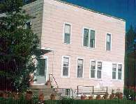
Larmons's Store

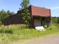
This building was Larmon's Store in the 40's through the 60's and  is residing in the South West corner of Hannibal, slightly west of the SM&P right of way. Picture on left is from the 1960's and right from 2003. Lawrence Larmon sold groceries and hardware. The building was made of brick rather than wood frame due to the abundance of building fires at that time we are told. Bricks came in on the SM&P.


The Automotive Service Station

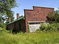
Kiddy-corner on the street was a building of the same vintage. This building shown the same vintage of blocks as used in Larmon's General Store store across the street. The two buildings were off of the Omaha right of way by a good city block, but may have been closer to the Stanley Merrill and Phillips railway. The bricks are the same and more than likely came from the same source via the Stanley Merrill and Phillips Railway. A walk around to the side revealed the nature of the structure. The building was Baker's Auto Service station up into the 60's. The station also supported gas pumps at one time. 

Wicke's Auto Service

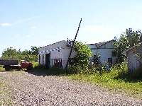
Wicke's auto service station for gas and repairs was near the original right of way into the 70's. It may have been built after the line was abandoned and the rails were removed. The street shown that the building is on may have been South of the Omaha right of way by at least the same amount as the brick buildings.


Other Buildings in Hannibal

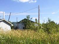
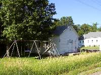
Trying to pick out other buildings near the right of way leads to speculation as to which may be at least 60 years old. Looks like an older 40's style church that remains or it may have been converted to a home recently


Special thanks to the following people for sharing information on Hannibal and the local businesses:

Emil Gerber
Gary Johnson 
Henry J. C. Schwartz
Nancy Lichtman
Dorothy Schwartz

  If you have any new information, stories, corrections, or pictures regarding this or any of the other towns along the Hannibal branch line, Please let me know, < E-mail > along with your permission to publish your personal memories in an attempt to keep the history available for future generations. Non-digital pictures and documentation will be returned upon request.

Thanks for looking

 Doug Stoll


ad pos61 ad pos63
ad pos62 ad pos64


Support this website by joining the Silver Rails TrainWeb Club for as little as $1 per month. Click here for info.